Most people who go hiking in Puerto Rico head straight to El Yunque. It makes sense — it’s the famous one, it’s accessible from San Juan, and it has the kind of infrastructure that makes visitors feel taken care of. Paved paths, clear signage, bathrooms, a gift shop.
Hiking in Puerto Rico’s central mountains is a different experience entirely. The trails are rougher, the crowds are almost nonexistent, the weather is less predictable, and there’s a rawness to it that the east coast rainforest doesn’t quite have. If you’re the kind of hiker who prefers earning the views over having them handed to you, the central mountains might be more your speed.
Here’s what to expect before you go.
What Makes Hiking in Puerto Rico’s Central Mountains Different

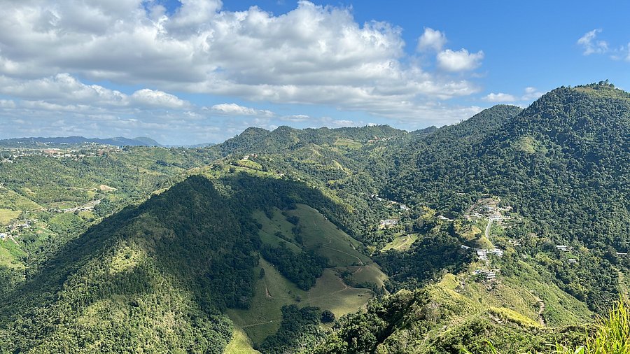
The central mountain range — the Cordillera Central — runs through the heart of the island, with peaks reaching over 4,000 feet. Cerro de Punta, the highest point in Puerto Rico, tops out at 4,390 feet. That elevation changes everything about the hiking experience.
The temperature is the first thing you’ll notice. It’s cooler up here than anywhere on the coast, sometimes by 10 to 15 degrees. Mornings can feel genuinely cold, especially when clouds settle into the valleys. You might start a hike in a light jacket and end up carrying it by midday — or the opposite if the weather shifts.
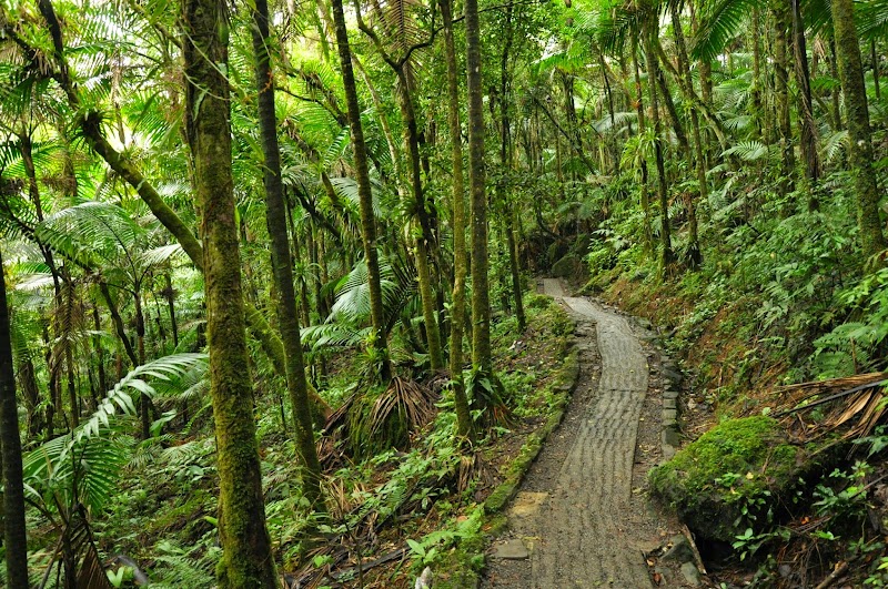
The mountains also receive significantly more rainfall than most of the island. Toro Negro forest gets around 110 inches of rain per year, which means the vegetation is perpetually green and the trails are frequently muddy. Even if it hasn’t rained in a couple of days, expect damp conditions. The forest floor rarely dries out completely.
And then there’s the infrastructure — or lack of it. Unlike El Yunque with its visitor centers and wooden walkways, the trails in the central mountains are largely unimproved. Signage is minimal or nonexistent on some routes. There are no bathrooms, no water fountains, no rangers stationed along the path. You come prepared or you don’t come at all.
The tradeoff is solitude. On a weekday hike in Toro Negro, you might not see another person for hours. The only sounds are birds, wind through the trees, and your own footsteps. For some hikers, that silence is the entire point.
Best Hiking Trails Near Orocovis
If you’re staying in the Orocovis area, you have several good options within a short drive.
Bosque Estatal Toro Negro
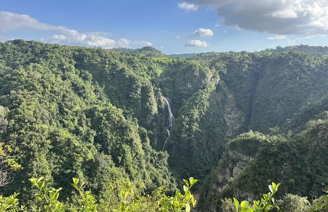
Toro Negro is the highest forest in Puerto Rico, covering about 7,000 acres across several municipalities including Orocovis, Villalba, Ciales, and Jayuya. It contains some of the island’s most important watersheds and the kind of cloud forest vegetation that feels prehistoric — giant ferns, sierra palms, trees draped in mosses and epiphytes.
The most popular trail is Camino El Bolo, a moderate hike that takes about 30 to 40 minutes to reach the observation tower. The trail itself is the experience as much as the destination: narrow paths through dense vegetation, the smell of wet earth, the occasional break in the canopy where light filters through. On clear days, the views from the tower are panoramic — you can see across the central range and, if you’re lucky, catch glimpses of both coasts.
The key word is “clear days.” The mountains make their own weather, and clouds often roll in by late morning. If you want the views, start early. If you get socked in by fog, the hike is still worth it — the forest takes on a different character in the mist.
Cerro Mime
Cerro Mime is shorter than Toro Negro but steeper — about 1.1 miles with significant elevation gain. The trail has sections exposed to direct sun, which can make it feel harder than the distance suggests. Unlike the shaded paths of Toro Negro, parts of Cerro Mime will have you sweating even on a cool day.
What you get for the effort is one of the better viewpoints in the area. The summit opens up to a panorama of the central range, green ridges layered into the distance. On clear mornings, the light is particularly good for photos. By afternoon, the haze and clouds usually move in.
Bring more water than you think you need. The climb is deceptively demanding, and there’s no shade to recover in on some sections.
Trails That Aren’t on the Map
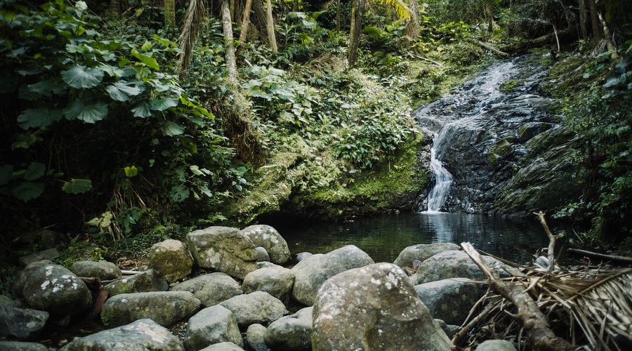
Beyond the established spots, there are trails in Barrio Saltos and surrounding areas that don’t show up on Google Maps or in any guidebook. Some follow old agricultural paths through coffee and plantain farms. Others lead to river access points or viewpoints that only locals know about.
If you want to explore beyond the obvious, ask around. A conversation at a roadside kiosk or with a property owner can point you toward spots that reward the extra effort. Just know that these trails are often unmarked and can be confusing if you don’t know where you’re going. Consider going with someone local the first time.
What to Bring
The mountains don’t have convenience stores. Whatever you need, you carry with you.
Footwear matters more here than on most trails. The paths can be muddy, rocky, and covered in roots — shoes with good grip are essential, not optional. Layers are worth the space in your pack because the temperature can shift quickly, especially if clouds move in or you gain elevation. A light rain jacket takes up almost no room and can save a hike if the weather turns.
Water is the one thing hikers consistently underestimate. The climbs are more demanding than they look, the humidity makes you sweat more than you realize, and there’s nowhere to refill. Bring more than you think you need.
Sunscreen and bug spray round out the basics. The mountain sun is strong even when it doesn’t feel hot, and while mosquitoes are less aggressive at higher elevations, they’re still around.
And bring a bag for your trash. The trails stay clean because hikers keep them that way.
Trail Conditions and Expectations
Be realistic about what you’re walking into. Trails can be muddy for days after rain — not just damp, but ankle-deep in places. Roots and rocks are constant features. Signage ranges from sparse to nonexistent depending on the trail. Cell service is unreliable in much of the forest, so don’t count on GPS or being able to call anyone if something goes wrong.
You probably won’t see other hikers, especially if you go midweek. The trails aren’t monitored or patrolled. If you twist an ankle two miles in, you’re dealing with it yourself until you can get back to your car.
None of this should scare you off — thousands of people hike these trails every year without incident. It’s just the reality of hiking in a place that hasn’t been packaged for tourism. Come prepared, pay attention, know your limits, and you’ll be fine.
When to Go
Early morning is the best time to hike, full stop. The air is cooler, the light is softer, and you’ll be done before the afternoon clouds roll in. Starting by 7 or 8 AM gives you the best chance of clear views from any summit or tower.
Seasonally, December through April is the dry season — trails are less muddy and rain is less frequent. The wet season from May through November brings greener landscapes and more dramatic cloud formations, but also more challenging conditions underfoot. Neither is wrong; it depends on what you’re looking for.
Avoid hiking right after heavy storms. The mountains are prone to landslides, and rivers can flash flood without warning. If it’s been raining hard for a few days, give it time to settle before heading out.
Weekdays are quieter than weekends at any time of year. Even Toro Negro, the most visited forest in the area, feels empty on a Tuesday morning.
Safety
The basics apply here as anywhere: tell someone where you’re going and when you expect to be back. If you’re unfamiliar with the area, go with someone who knows the trails — or at least stick to the more established routes until you get your bearings.
Carry more water than seems reasonable. Stay aware of the weather; conditions can change quickly in the mountains. Know your own fitness level and don’t push beyond it just because a trail looks short on paper.
Emergency services exist, but response times in the mountains are slow. There’s no quick rescue if something goes wrong. That’s not meant to frighten you — it’s just the math of being in a remote area. Hike accordingly.
The Payoff

Hiking in Puerto Rico’s central mountains isn’t the easy option. The trails are rougher, the logistics require more thought, and you’ll work harder for every view.
But that’s also what makes it worth doing.
You’ll see a side of the island that most visitors never experience — the quiet interior, the old forests, the villages tucked into valleys. You’ll have trails to yourself, earn your views with sweat, and remember what it feels like to be somewhere that hasn’t been optimized for your convenience.
The central mountains don’t hand you the experience. They just provide the space and let you make of it what you will.